Place in News | Current Affairs | Vision IAS
MENU
Home

Periodically curated articles and updates on national and international developments relevant for UPSC Civil Services Examination.

Quick Links

High-quality MCQs and Mains Answer Writing to sharpen skills and reinforce learning every day.

Watch explainer and thematic concept-building videos under initiatives like Deep Dive, Master Classes, etc., on important UPSC topics.

ESC
A map of Northeast Africa highlighting Sudan in orange. Sudan is bordered by Egypt to the north, the Red Sea, and Eritrea to the east, Ethiopia to the southeast, South Sudan to the south, Central African Republic to the southwest, Chad to the west, and Libya to the northwest. The capital, Khartoum, is marked with a star.

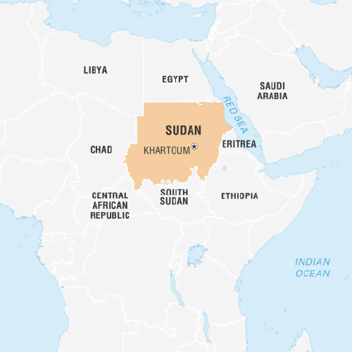
Sudan (Capital: Khartoum)

Dam collapses in eastern Sudan after heavy rainfall claims multiple lives.

Political features 

  • Land Borders: by Egypt (north), Eritrea and Ethiopia (east), South Sudan (south), Central African Republic and Chad (west), and Libya (northwest).
  • Maritime Border: Red Sea (east).

Geographical features

  • Highest point:  Deriba Caldera (Crater Lake) at Jebel Mara.
  • Major Rivers: Nile, Tekeze etc.
  • Climate: Varies from north to south. Northern part is a desert climate, receiving little rainfall, shifting to semi-arid and then tropical savannah towards south. 
Watch Video News Today

Explore Related Content

Discover more articles, videos, and terms related to this topic

Title is required. Maximum 500 characters.

Search Notes

Filter Notes

Loading your notes...
Searching your notes...
Loading more notes...
You've reached the end of your notes

No notes yet

Create your first note to get started.

No notes found

Try adjusting your search criteria or clear the search.

Saving...
Saved

Please select a subject.

Referenced Articles

linked

No references added yet