
India’s first satellite, Aryabhata, completed 50 years.
About Aryabhata Satellite
- Built by ISRO to conduct experiments in X-ray astronomy, aeronomics, and solar physics.
- Named after the ancient Indian mathematician and astronomer.
- Launched in 1975, by Soviet Kosmos-3M rocket from Volgograd Launch Station (present Russia)
- Made India the 11th country in the world to send a satellite into orbit.
Government provided grants for EV startups under Project EVolutionS.
About Electric Vehicle Solutions led by Startups (EVolutionS) Programme
- Launched by the Department of Science and Technology (DST),Ministry of Science & Technology.
- Implemented in collaboration with Ministry of Heavy Industry (MHI) and Automotive Component Manufacturing Association of India (ACMA).
- Objective: To aid selected startups in pilot demonstration, testing, validation of components and establishing industry connects for speedy translation of EV solutions to market.
- It covers components for electric two-, three- and four-wheelers (including L5, e-rickshaw and e-cart), e-buses and EV public charging infrastructure.
- Startups that have demonstrated indigenous capability in developing materials/components will get a grant of ₹50 lakh, including ₹30 lakh in the form of equity-linked instruments.
Article Sources
1 sourceThe Arts College building of Osmania University (OU), Hyderabad, Andhra Pradesh, has become the third structure in India to receive a trademark for its exterior design.
- The first two were the Taj Mahal Palace Hotel and the Bombay Stock Exchange.
Benefits of Trademarking
- Gives OU exclusive rights to use the building’s image for commercial purposes and protection from unauthorised copying.
- Helps preserve the unique architectural identity.
Architectural Significance of the Buidling
- Built in December 1939, the building reflects the Osman Shahi Architectural Style.
- The Architecture is a blend of Qutub Shahi and Mughal styles, with influences from Kakatiyan temples, Ajanta, and Ellora.
- Uniquely, it lacks a dome, unlike other Nizam-era structures.
Kokborok Sahitya Parishad sought inclusion of Kokborok language in the Eighth Schedule of the Constitution.
About Kokborok Language:
- The word "Kokborok" comes from "Kok," meaning "verbal," and "Borok," meaning "people" or "human."
- It is the language of Borok people who are geographically known as Tripuris.
- It is the mother tongue of communities namely Debbarma (Tripuri) Reang, Jamatia, Noatia, Kalai, Rupini, Murasing, Uchoi etc.
- It is recognised as one of the State languages of Tripura.
- It is part of the Sino-Tibetan language family.
- It is classified as Vulnerable by the UNESCO Atlas of the World's Languages in Danger.
Tags:
Indian Air Force is participating in Exercise Desert Flag-10.
- It is a premier multinational air combat exercise being hosted by the United Arab Emirates (UAE).
Tags:
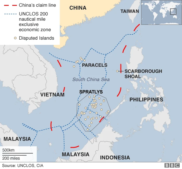
China alleged intrusion by the Philippines in the contentious Scarborough Shoal waters of the South China Sea (SCS).
- SCS is a marginal sea in the western Pacific Ocean bordering Brunei Darussalam, Malaysia, Indonesia, the Philippines, Singapore, Thailand, Vietnam and China.
About Scarborough Shoals
- Scarborough is the largest atoll in the South China Sea, located about 220kms to west of Philippines.
- It is located inside Exclusive Economic Zone (EEZ) of Philippines but has been claimed by China as its ancestral territory (demarcated by nine-dash line) since the 13th century.
- Other disputed islands in SCS: Paracel and Spratly island
India has dispatched a second batch of batteries of BrahMos Missile system to the Philippines.
About BrahMos
- Jointly developed by India and Russia
- A long-range supersonic cruise missile that can be launched from land, sea and air.
- Two-stage system:
- 1st stage (Solid propellant booster): Gives the initial supersonic speed.
- 2nd stage (Liquid ramjet): takes the missile closer to 3 Mach speed in cruise phase.
- Range: Up to 290 km
- Special Capabilities
- "Fire and Forget" technology
- Shorter flight times lead to lower target dispersion and quicker engagement
- Pin point accuracy
Tags:
ISRO satellite CROP estimated wheat Crop Area and production in India.
- It has estimated that the total wheat production from 8 major wheat growing States of India would be 122.724 million tonnes as on March 31, 2025.
About CROP
- It is a semi-automated, scalable framework, developed by National Remote Sensing Centre (NRSC)/ISRO.
- It enables the near real-time monitoring of crop sowing and harvesting during the Rabi season across India.
- It uses Optical and Synthetic Aperture Radar (SAR) remote sensing datasets from EOS-04 (RISAT-1A), EOS-06 (Oceansat-3), and Resourcesat-2A, for the Rabi season, 2024-25.
Tags:


