- Recently, the Ministry of Environment and Forests issued further guidelines on its Green Credit Programme (GCP).
- In February 2024, the ministry released rules for calculating green credit for tree plantations.
- The new guidelines have been issued for the preparation of cost estimates for the eco-restoration of degraded forests.
- Key Provisions of the new guidelines
- The focus of work for plantation on degraded forest areas under the GCP to be on eco-restoration of degraded forests.
- Number of trees to be planted depends upon site characteristics and may vary as per the site conditions.
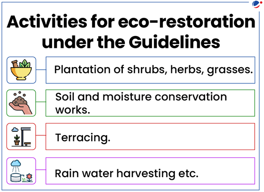
- Activities for eco-restoration are not to be limited to the plantation of trees and also include other activities (see image).
- Fencing may also be provided for protection against anthropogenic pressures.
- Preference to indigenous species.
- Plantation of high-quality seedlings to ensure their healthy growth.
- Retention of Naturally growing seedlings.
- Cost estimates may be titled as 'Ecorestoration of the identified degraded forests'.
- A CPCB Report to NGT showed that 80% of environmental funds remained unutilized.
- Despite collecting a total of Rs 777.69 crore through Environment Protection Charge (EPC) and Environmental Compensation, the Central Pollution Control Board (CPCB) has utilized only 20% of these funds.
- These funds were utilized for: R&D on air quality, health impact studies, infrastructure development for air and water quality surveillance, remediation of contaminated sites etc.
- CPCB receives compensation under two heads:
- Environment Protection Charge (EPC): The dealer/manufacturer is required to pay one percent EPC for specified new diesel vehicles, registered only in Delhi and NCR.
- It is received as per the order of Supreme Court.
- Environmental compensation is a policy instrument for the protection of the environment which works on the Polluter Pay Principle.
- It is received as per orders of NGT.
- It is utilized to protect the environment through the strengthening of laboratories/monitoring networks, projects in compliance of NGT orders, capacity building of pollution control boards, etc.
- Environment Protection Charge (EPC): The dealer/manufacturer is required to pay one percent EPC for specified new diesel vehicles, registered only in Delhi and NCR.
- CPCB is a Statutory Body formed under the Water (Prevention and Control of Pollution) Act, 1974.
- Also, it is entrusted with powers and functions under the Air (Prevention and Control of Pollution) Act, 1981.
- Functions under Ministry of Environment, Forest and Climate Change
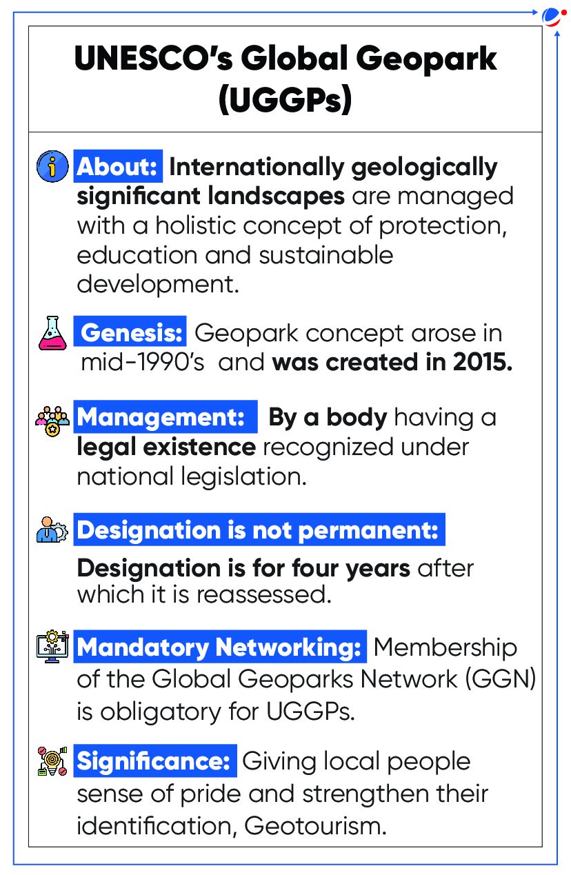
- UNESCO endorsed the addition of 18 new Geoparks to the Global Geoparks Network (GGN).
- The latest addition raises the number of total Geoparks to 213 which are spread across 48 countries (no geopark in India).
- Some major geoparks added to GGN are:
- Land of Extinct Volcanoes (Poland): Features distinctive remnants of Paleozoic and Cenozoic volcanoes
- Impact Crater Lake (Finland): Europe's largest impact crater lake formed through a collision with a meteorite 78 million years ago.
- Uberaba (Brazil): Its tagline ‘Land of the Giants’ refers to its rich palaeontological heritage.
Global Geoparks Network (GGN)
|
- Climate Technology Centre and Network (CTCN) marks its 10th anniversary.
- About CTCN
- Headquarters: Copenhagen, Denmark.
- Established in 2014, it is the implementation arm of the Technology Mechanism of the United Nations Framework Convention on Climate Change.
- Technology Mechanism was established in 2010 to accelerate and enhance climate technology development and transfer.
- It is hosted by the UN Environment Programme.
- It promotes accelerated transfer of environmentally sound technologies for low carbon and climate resilient development at the request of developing countries.
- 1MYAC (One Million Youth Actions Challenge) is promoted by the One UN Climate Change Learning Partnership (UN CC: Learn).
- About 1MYAC
- Aims to encourage youth aged 10 to 30 years old to take concrete actions for a more sustainable future.
- It works to promote four Sustainable Development Goals (SDGs)
- It includes SDG 6 (clean water and sanitation), SDG 12 (responsible consumption and production), SDG 13 (climate action) and SDG 15 (life on land).
- UN CC: Learn is a collaborative initiative of 36 multilateral organizations working together to help countries build the knowledge and skills they need to take action on climate change.
- UN Development Programme unveiled Climate Promise 2025, the next stage of its Climate Promise Initiative.
- About Climate Promise Initiative
- It is an initiative to support developing countries in their climate action.
- It is the world’s largest offer of support to developing countries on NDC (Nationally Determined Contribution) enhancement and implementation.
- Each Party to the Paris Agreement is required to establish an NDC, which includes targets for mitigating the greenhouse gas emissions and for adapting to climate impacts.
- Climate Promise 2025 aims to align the next generation of developing countries’ NDCs to the goals of the 2015 Paris Climate Agreement.
- Atlas, released by the National Remote Sensing Centre (NRSC), aims to systematically examine land utilization patterns to offer invaluable insights into the evolving dynamics of our environment.
- Key highlights of the Atlas
- Agriculture: Over the past 17 years, Kharif and Rabi cropland has expanded by 46.06% and 35.23% respectively, as fallow land diminished by 45.19%.
- Double/ triple/ annual cropping areas have also increased by 82.22%. (Double/ triple cropland are areas where crops are sown and harvested twice/ thrice in one crop year. Annual crops are perennial and grow throughout the year such as sugarcane)
- Since 2005, shifting cultivation increased until 2016-17, after which it witnessed a decline.
- Water resources: Indicated by minimum water body surface showed an increase of 146 % since 2005.
- Built-up land: Shows an increase with an overall growth of 30.77% since 2005.
- Built-up area refers to an area with buildings, paved surfaces, commercial and industrial sites, and urban green areas.
- Wastelands (degraded and unproductive lands) contributed significantly to built-up area expansion by 12.3%.
- Agriculture: Over the past 17 years, Kharif and Rabi cropland has expanded by 46.06% and 35.23% respectively, as fallow land diminished by 45.19%.
- Reasons for changes in LULC: Improved availability of farm inputs such as improved irrigation facilities, urbanization and infrastructure development, etc.
- Released by: World Meteorological Organization (WMO)
Key Findings
- 2023 was the warmest year on record, with the global average near-surface temperature at 1.45 degree Celsius above the pre-industrial baseline.
- Extreme climate conditions exacerbated humanitarian crises, with millions experiencing acute food insecurity and hundreds of thousands displaced from their homes.
- Greenhouse gas levels, surface temperatures, ocean heat and acidification, etc. reached record high.
- International Energy Agency (IEA) released Clean Energy Transitions Programme (CETP) Annual Report 2023.
About Clean Energy Transitions Programme (CETP)
- It was launched in 2017 by IEA.
- It is leading the global fight against climate change by accelerating clean energy transitions.
- Under CETP, IEA provides technical assistance, insights etc.
- Its objectives are aligned with 2015 Paris Agreement and the Sustainable Development Goals.
- United Nations Environment Programme (UNEP) released Global Status Report for Buildings and Construction (Buildings-GSR) 2024.
- Report was published jointly by UNEP and Global Alliance for Buildings and Construction (GlobalABC).
Key findings
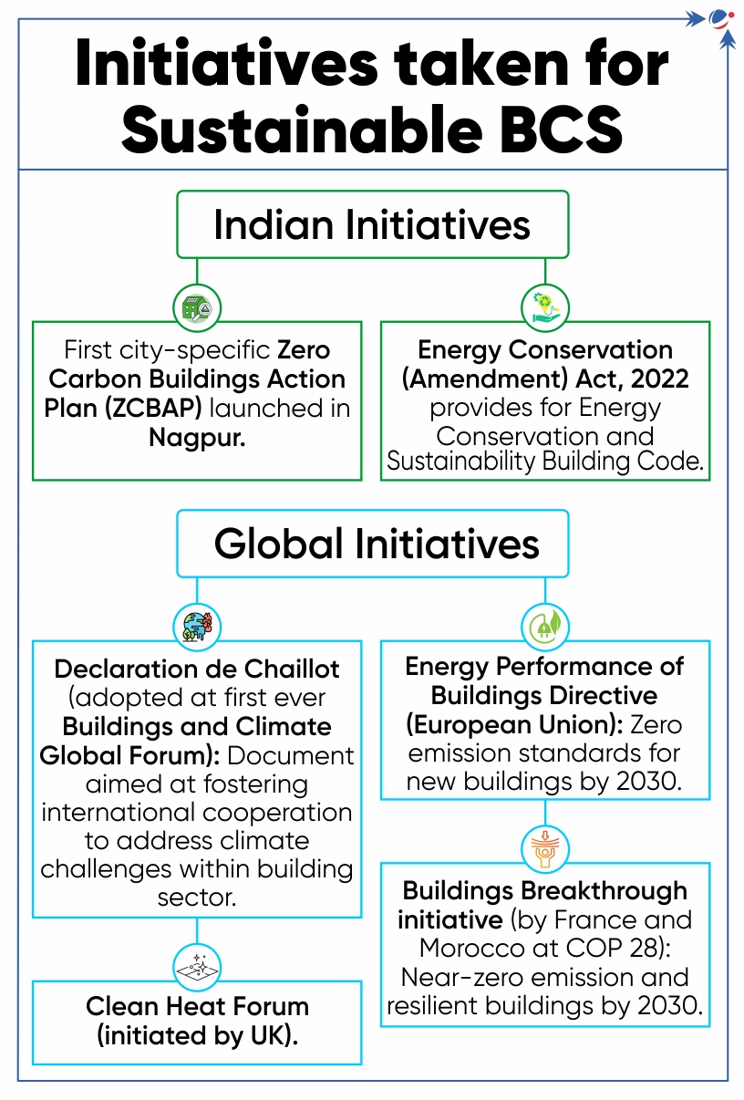
- Building and Construction Sector (BCS) accounts for about 21% of global Greenhouse Gas (GHG) Emissions.
- In 2022, buildings were responsible for 34% global energy demand and 37% of energy and process-related carbon dioxide (CO2) emissions.
- India is attributing 40% of its CO2 emissions to buildings.
- Need to Decarbonise BCS:
- Limit global warming to 1.5°C (Paris agreement) and achieve net zero by 2050 by reducing embodied carbon in building materials.
 About GlobalABC
Challenges in Decarbonising BCS
Recommendations
|
- As per a recent study the northern permafrost region has been projected to shift from a net sink to a net source of carbon under global warming.
- This is first ever comprehensive estimation of quantities of emission and capturing of carbon dioxide (CO2), methane (CH4) and nitrous oxide (N2O) between 2000 and 2020 in and around the Arctic.
- The permafrost region overall emits methane and nitrous oxide. However, the research was uncertain whether it was a source of a sink of carbon dioxide.
About Permafrost
- Permafrost is a permanently frozen layer on or under Earth's surface. It consists of soil, gravel, and sand, usually bound together by ice.
- Permafrost usually remains at or below 0°C (32ºF) for at least two years.
- Permafrost is often found in Arctic regions such as Greenland, the U.S. state of Alaska, Russia, China, and Eastern Europe.
- As Earth’s climate warms, the permafrost is thawing. That means the ice inside the permafrost melts, leaving behind water and soil.
Impact of thawing permafrost
- Net source of carbon: As permafrost thaws, microbes begin decomposing plant material in the soil. This process releases greenhouse gases to the atmosphere
- Disease Outbreak: When permafrost thaws, so do ancient bacteria and viruses in the ice and soil. These newly-unfrozen microbes could make humans and animals very sick.
- Infrastructure stability: Thawing permafrost can destroy houses, roads and other infrastructure as towns and cities built on top of what was once considered permanently frozen ground.
- NOAA’s Coral Reef Watch (CRW) and International Coral Reef Initiative (ICRI) confirm 4th global mass coral bleaching event.
- Mass bleaching of coral reefs, since early 2023, has been confirmed in at least 53 countries, territories, and local economies including Australia’s Great Barrier Reef.
- It is second such event in the past 10 years with earlier event lasting from 2014 to 2017.
- Corals are invertebrate animals belonging to a large group of animals called Cnidaria.
- Generally classified as “hard coral” (reef building corals having rock-like calcareous skeleton) or “soft coral”.
- Coral reefs are formed by polyps of hard corals, which establish symbiotic relationship with microscopic algae, called zooxanthellae, which give them their characteristic colours.
- Growth Conditions for Coral Reefs: Warm (23–29°C), salty (32-42 ppt), clear, shallow marine waters with stable temperatures and abundant sunlight.
- Significance of reefs: Often called rainforests of the ocean due to high biodiversity and productivity, support around 25% of marine life, minimize storm impact, promote tourism, act as carbon sink etc.
- Coral Bleaching: When corals are stressed by changes in conditions such as temperature, light, or nutrients, they expel symbiotic algae, causing them to turn completely white.
- Factors Responsible: Increased Ocean temperature due to climate change, runoff and pollution, extreme low tides, Ocean acidification etc.
Measures Taken for conserving coral reefs
- Global: ICRI, Global Fund for Coral Reefs, Global Coral Reef Monitoring Network (GCRMN), Coral Triangle Initiative (CTI), etc.
- Coral Triangle is a marine area located in the western Pacific Ocean. It includes the waters of Indonesia, Malaysia, Philippines, Papua New Guinea, Timor Leste and Solomon Islands.
- India: Marine Protected Areas (MPAs), Integrated Coastal Zone Management (ICZM) and coral restoration through Biorock technology (technique to preserve coral reefs by constructing materials under the sea that resemble rocks), etc.
- Gape limitation is a concept in ecology that refers to the physical constraint on the size of prey that a predator can consume. This limitation is primarily determined by the size of the predator’s mouth or “gape”.
- This means, Small predators can only eat small prey, while bigger predators can eat bigger prey.
- For example, lions can take down large prey like zebras due to their large gapes, while smaller predators like hawks are limited to eating rodents or insects.
Importance of Gape limitation in ecology
- Shaping Food Webs: Gape limitation dictates the dietary choices of predatory and ultimately sculpting the intricate structure of food webs.
- It determines who eats whom, influencing the energy flow and interconnections between different species.
- Driving adaptations: Some may evolve cooperative hunting strategies or the ability to use tools to capture larger prey beyond their gape size. Others may adapt to specialize in consuming smaller prey within their gape range.
- Crocodiles use cooperative hunting techniques or tools to capture larger prey beyond their usual gape size.
- Regulating predator-prey balance: By limiting the range of prey sizes accessible to predators, gape limitation plays a role in regulating predator-prey population dynamics.
- This contributes to maintaining the delicate balance within an ecosystem.
- Predicting ecosystem changes: Understanding gape limitation allows scientists predict how environmental disturbances, such as introduction of invasive species or removal of top predators, impact the overall ecosystem structure and function.
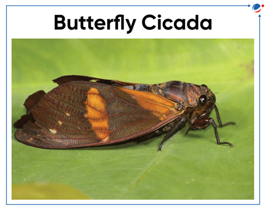
- A new species of cicada discovered in Meghalaya.
About Cicada
- It belongs to genus Becquartina and marks the first-ever record of this genus in the country
- The species in this genus are often called “Butterfly cicadas” because of their colourful wings.
- The present discovery extends the distributional range of the genus Becquartina from Southeast Asia into Northeast India.
- It increases the total number of known Becquartina species to seven.
- Paleontologists have unearthed a giant predator snake in Gujarat’s Panandhro Lignite Mine in Kutch named Vasuki Indicus.
About Vasuki Indicus:
- Likely lived 47 million years ago during the Middle Eocene Period.
- Length range: 36-49 feet.
- It’s a member of the Madtsoiidae snake family that appeared roughly 90 million years ago but went extinct about 12,000 years ago.
- It spread from India through southern Eurasia and into north Africa after the Indian subcontinent collided with Eurasia around 50 million years ago.
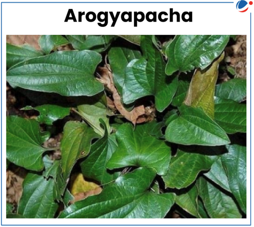
- 'Arogyappacha' (Trichopus zeylanicus) found endemic to Agastyar hills of Kerala is used by the local 'kani' tribe as a health food for getting instant stamina, ever green health and vitality.
About Arogyapacha
- The term arogyapacha literally mean 'the green that gives strength’.
- Arogyapacha is a small medicinal plant with slender stems and thick leaves. It grows in shade near the banks of streams and rivulets. Only tender fruits of this plant are edible.
- Medicinal properties: Anti-oxidant, anti-microbial, anti-inflammatory, anti-tumour, anti-ulcer, anti-hyperlipidemic, hepatoprotective and anti-diabetic, etc.
- Arogyapacha is a subspecies of Trichopus zeylanicus.
- The subspecies found in India is called Trichopus zeylanicus travancoricus.
- Though the main species, Trichopus zeylanicus, is found in Sri Lanka and Thailand, only the Indian variety is proved to have medicinal qualities.
- A drug named ‘Jeevani’ has been developed using “Arogya Pacha” with three more ingredients by Tropical Botanic Garden and Research Institute (TBGRI), Thiruvananthapuram, Kerala.
- Kani Tribes gets a share of 50% on commercial returns.
- Researchers have uncovered a vast reservoir of water, dubbed the "Ringwoodite Ocean," concealed within the Earth's mantle, over 700 kms beneath the surface.
- "Ringwoodite Ocean" is a vast reservoir of water trapped within the mineral ringwoodite in the Earth's mantle.
About Ringwoodite
- It is a vivid blue mineral formed under high temperatures and pressures in Earth's mantle.
- It is one of the most typical high-pressure mineral in meteorites.
- Named after Australian earth scientist Alfred E. Ringwood who studied polymorphic phase transitions in common mantle minerals, olivine and pyroxene.
- Global Society for Preservation of Baobabs and Mangroves has initiated a mission to rejuvenate baobab trees.
About Baobab Tree (Genus: Adansonia)
- Long-lived deciduous, small to large trees from 20 to 100 ft tall with broad trunks and compact tops.
- Grows in Africa, Madagascar and Australia.
- Also found in Mandu, in Dhar district of Madhya Pradesh.
- Also known as upside-down tree, because in dry season they are devoid of leaves, and their bare grey and gnarled branches resemble roots.
- Fiber from bark is used to make rope, cloth, musical instrument strings etc.
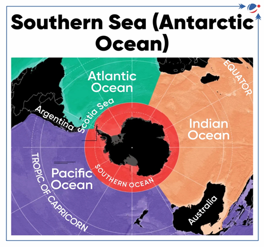
- Scientists discover the reason behind the cleanest air in the Southern Ocean region.
- Clean air refers to the low levels of aerosols in the atmosphere.
- Aerosol is the suspension of fine solid particles or liquid droplets in air.
Reasons for the low level of aerosols in Southern Ocean region
- Reduced Human activity in the region, resulting in minimal emissions and fossil fuel usage.
- Phytoplankton that are a source of airborne sulfate particles are fewer in winter, resulting in fewer sulfate particles during winter.
- Role of Clouds and Rain
- Honeycomb-structured clouds play a crucial role in the region's climate.
- Open honeycomb clouds allow sunlight to pass and tend to produce more intense, sporadic rainfall, which "washes" the aerosols out.
- These clouds are more common in the winter.
- Closed honeycomb clouds reflect sunlight leading to low rainfall and thus less effective at removing aerosols.
About Southern Ocean (Antarctic Ocean)
- Geologically the youngest of the world's oceans.
- Dominated by the clockwise circulating Antarctic Circumpolar Current.
- Known for its strong winds, intense storms, dramatic seasonal changes, and cold temperatures.
- Geologists predict potential emergence of a new ocean at the Afar Triangle (also known as the Afar Depression), located in the Horn of Africa.
About Afar Triangle
- It represents the northernmost portion of the Great Rift Valley.
- It is on one of the most geologically active regions on earth, where Nubian, Somali and Arabian Plates converge.
- It will be inundated by Red Sea and the Gulf of Aden when new ocean basin will be formed. This could lead to the birth of a distinct continent in East Africa.
- It encompasses sections of Eritrea, Djibouti, and Ethiopia.
- Awash River is the main river that flows through the Afar Triangle.
- Study has found that the desert which emerged due to the drying up of the Aral Sea has made Central Asia a much dustier place.
About Aral Sea
- It was once-large saltwater lake of Central Asia.
- Lies on the boundary between Kazakhstan to the north and Uzbekistan to the south.
Other important lakes that shrunk in last few decades:
- Lake Urmia: Lies in the bottom of the large central depression of the Azerbaijan region in northwestern Iran.
- Lake Hamoun: Freshwater Lake in Iran on Iran – Afghanistan border.
- VVR, also known as volcanic smoke rings, are generated when gas, predominantly water vapor, is released rapidly through a circular vent in the volcanic crater.
- Mt Etna is the world’s most active volcano, located on the east coast of Sicily (Italy).
- Also, it is the largest volcano of Europe.
- It lies in the highly active tectonic zone of Mediterranean Sea region which is part of the Mid-continental Volcanic Belt.
- The other important belt includes Circum pacific (ring of fire) and Mid-Atlantic belt.
Why Mediterranean Sea region has highly active tectonic zone?
- Located on the convergent boundary between the Eurasian and African continental plates, and other minor plates.
- Convergence of plates creates subduction zone in western part of sea, leading to formation of volcanoes.
- A subduction zone is a collision between two of Earth's tectonic plates, where one plate sinks into the mantle underneath the other plate.
- Chains of submarine volcanoes have been created in the sea.
- The important volcanoes in the region are Mt Vesuvius, Stromboli, etc.
- Recently, India and the US have decided to reactivate the IndOOS, which had been in despair since the COVID pandemic
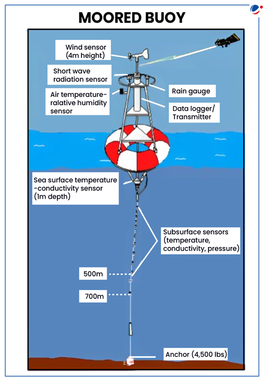
About IndOOS:
- It is a network of 36 moored buoys on the high seas to collect high-resolution ocean and atmospheric data for weather forecasts.
- A moored buoy is an oceanographic instrument designed to stay in one place and has multiple sensors to collect data.
- Established in 2006, its objective include:
- To provide sustained, high-quality oceanographic and marine meteorological data for weather and climate forecasts and environmental assessments.
- To foster agreements and partnerships among Indian Ocean countries and to enhance their long-term monitoring and forecasting capacity.
- It was initially set up to understand and forecast the monsoon.
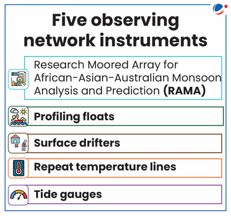
- Components of IndOOS: It is a system of five observing network instruments deployed in the Indian Ocean to measure:
- Seawater temperature,
- Salinity,
- Ocean currents,
- Atmospheric humidity, and
- Wind.
- Researchers have shown that increased ice melting may have delayed need for adding negative leap second.
- Negative leap second is a second that is subtracted from clocks to keep them aligned with Earth's rotation.
- It is done when Earth is spinning more quickly and length of day is decreasing.
- It is opposite of positive leap second (one-second addition to clocks).
- It is done when length of day is rising (Earth is spinning more slowly).
- So far, there have been 27 positive leap seconds, but no negative leap seconds.
- Recently, Bengaluru experienced a rare celestial phenomenon known as ‘Zero Shadow Day’.
About Zero Shadow Day
- It occurs when the sun aligns perfectly overhead, causing vertical objects to cast no shadows.
- This phenomenon occurs twice a year (once during Summer Solstice and once during Winter Solstice) in regions situated between the Tropic of Cancer and the Tropic of Capricorn.
- The zero shadow days are different for different places.


