
Why in the News?
IIT Delhi created the first hi-resolution Indian Landslide Susceptibility Map (ILSM).
About Indian Landslide Susceptibility Map (ILSM)
- A landslide susceptibility map divides the terrain into zones based on the likelihood of landslide occurrence.
Key Feature of ILSM
- Innovative Framework for High-Resolution Landslide Mapping: Embracing big data and use of multiple machine learning models with different underlying principles.
- The map model incorporates 16 landslide conditioning factors such as height, slope, soil composition, road distance, river proximity, vegetation cover, precipitation, etc.
- High Spatial Resolution Mapping: Map has a spatial resolution of 100 metres with over 95% accuracy.
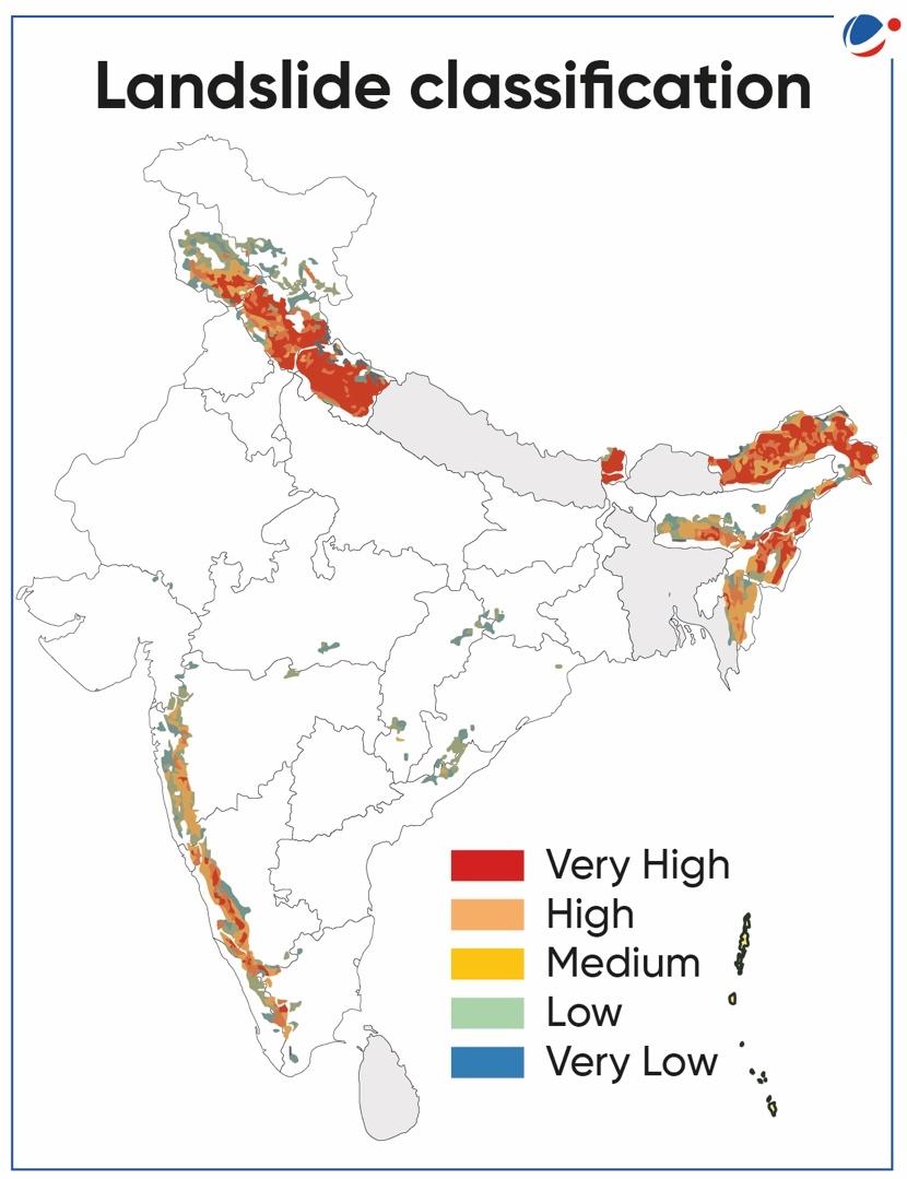
- Multi-Class Vulnerability Classification: Divides India into Five Vulnerability Classes (refer to map).
Key Findings of ILSM
- Overall Landscape Susceptibility to Landslides in India: Map classifies 13.17% of India's geographical area as susceptible to landslides.
- 4.75% of the area is categorized as "very highly susceptible."
- Geological Survey of India estimates a slightly lower figure at 12.6%.
- Regional Variation in Susceptibility:
- Sikkim has the highest percentage of land area (57.6 %) susceptible to landslides.
- Arunachal Pradesh has the highest absolute area susceptible to landslides.
- Kerala, among the non-Himalayan regions, exhibits the highest area susceptible to landslides.
- Identification of New Landslide-Prone Zones: Eastern Ghats show landslide-prone zones identified by the map.
- These zones were not reported by previous models or government records.
Significance of ILSM
- Policy Formulation and Implementation: It serves as a foundation for the formulation and implementation of policies related to disaster risk reduction, providing a data-driven approach for governments and agencies.
- Scientific Understanding of Landslide Dynamics: Helping researchers and scientists study factors contributing to landslides and refine prediction models.
- Early Warning and Preparedness: The map provides crucial information for identifying areas with high susceptibility to landslides, enabling early warning systems and preparedness measures.
About Landslide
- Phenomena: Landslides occur when gravity forces pushing on hill slope material exceed the frictional forces holding the material in place, causing slope failure.
- Landslide susceptibility represents this potential for slope failure.
- Due to steep slopes and heavy rainfall most of the landslides occur in the northwest Himalayas followed by the northeast Himalayas and the Western Ghats.
- Causes: Landslides are caused by complex interactions of geological, geomorphological, hydrological, and meteorological characteristics.
- Geological Factors Influencing Landslides in the Himalayas: The Himalayas are composed of sedimentary rocks which are prone to denudation and erosion.
- Steep slopes and rapid rivers contribute to toe erosion making the slope unstable.
- Most of the landslides in the Himalayas are rockfalls.
- Geological Dynamics of Landslides in the Western Ghats: The presence of basalt rocks and gentle-sloped rivers in the Western Ghats resulted in fewer rockfalls. However, weathering due to heavy rainfall has led to the development of a thick layer of regolith, thereby leading to mudslides.
- Role of Rainfall in Landslide Triggering: Rainfall intensity and duration as critical factors for landslide initiation.
- Western Ghats require less rainfall to trigger landslides when compared to the Himalayas due to the high soil depth in Western Ghats.
- High soil depth allows more water retention and an increased porewater pressure ultimately leading to landslides.
- Anthropogenic Contributions to Landslide Risk: Road development and construction contribute to slope instability.
- Geological Factors Influencing Landslides in the Himalayas: The Himalayas are composed of sedimentary rocks which are prone to denudation and erosion.
Initiatives Taken by India
- National Landslide Risk Management Strategy released by National Disaster Management Authority (NDMA): The strategy document brings out the message of the need to strengthen and mainstream landslide disaster preparedness, mitigation, response and relief mechanisms through
- Landslide Hazard Zonation: It covers aspects of reliability and validation of landslide zoning maps in the Indian scenario and proposes a plan of activities for landslide zoning.
- Landslide Monitoring and Early Warning System
- Awareness generation and capacity building
- Preparation of Mountain Zone Regulations and Policies
- Stabilization and Mitigation of Landslide and Creation of Special Purpose Vehicle (SPV) for Landslide Management
- National Landslide Susceptibility Mapping (NLSM) Programme: Launched in 2014-15, under it Geological Survey of India has completed landslide susceptibility mapping of 4.3 lakh sq. km. of landslide-prone areas in the country.
- Landslide Atlas of India: The database covers landslide-vulnerable regions in 17 states and 2 UTs of India in the Himalayas and Western Ghats.
- Prepared by National Remote Sensing Centre (NRSC) of ISRO.
Conclusion
Adopting area-specific measures is crucial for landslide prevention. Enforce restrictions on construction, roads, and dams in vulnerable areas. Complement with positive actions like large-scale afforestation, bund construction for water flow control, and encourage terrace farming in northeastern hill states where Jhumming (Slash and Burn/Shifting Cultivation) is practised.


