
Why in the news?
ISRO is planning to launch 50 satellites for intelligence gathering in the next 5 years.
More on the news
- This will involve creating a layer of satellites in different orbits with a capacity to track the movement of troops and image thousands of kilometres of area.
- It will improve the ability of satellites to detect changes, and will bring in more of AI-related and data-driven approach to analyze geospatial data.
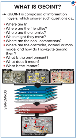
Geospatial intelligence
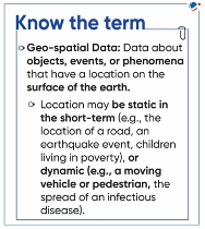
- Geospatial intelligence is an intelligence discipline that analyzes geospatial data to better understand and visually depict human activity at specific geographic location.
- It uses imagery to survey and assess human activity and physical geography anywhere on Earth.
- Geospatial intelligence usually collects and integrate data from a network of technologies, including satellites, mobile sensors, ground-control stations and aerial images
- This data will be used to produce real-time maps and simulations to help identify when, where and to what extent a threat is likely to emerge. E.g., Disaster, Wild fire, Hybrid warfare etc.
Significance of geospatial technology enabled Intelligence gathering
- Strengthening India’s intelligence architecture: Geospatial data overlying on high-resolution satellite images substantially enhances the precision and reliability of intelligence, surveillance, and reconnaissance activities.
- Advancing situational awareness: With its unique ability of real-time monitoring, geospatial data can provide actionable insights for quick and secure decision-making to handle critical insurgencies.
- Strengthening Border Security and Coastal Surveillance System, e.g., Mapping of terrain and hotspots of border crossing.
- Preventing and/or disrupting potential internal and external security threats, e.g., tracking infiltration and monitoring camps of terrorists, left wing extremists etc.
- Targeting & Battle Damage Assessment: It can help analyze enemy vulnerability, determine how best to achieve adequate military results (e.g., avoiding civilian casualties), and plan future targeting action.
- Tackling new and emerging threats: Geospatial analytics can help to predict and counter new threats like cyber-attacks, hybrid warfare, stealth weaponry etc. which endanger critical infrastructure of the nation.
- Disaster Management: Geospatial data can play significant role in risk reduction, Preparedness, Response and rescue, and recovery phase of disaster.
- Military and civilian logistics: By using geospatial intelligence, Medical and health service support can be provided in short time. It will also improve the movement of troops, supplies, arms, and ammunition across the nation.
- Operations Support: Geospatial intelligence will help in obtaining the last equipment activity situation, and finally helping in maintaining decision superiority.
- Maritime Domain Awareness (MDA): Expanding regional coverage of geospatial intelligence to monitor the maritime domain more comprehensively leads to securing the Indian Ocean region.
India’s steps towards strengthening Geospatial Intelligence
|
Conclusion
In the context of India, fast-evolving situation across multiple active theatres and a large diverse border (15k km Land borders and 7.5k km coastline) create an ideal case for use of geospatial intelligence most effectively to support the solider on the ground.

