
Why in the News?
Recently, India unveiled its updated Seismic Zonation Map as per revised Earthquake Design Code released by Bureau of Indian Standards (BIS).
Key Highlights of the Updated Seismic Zonation Map of India
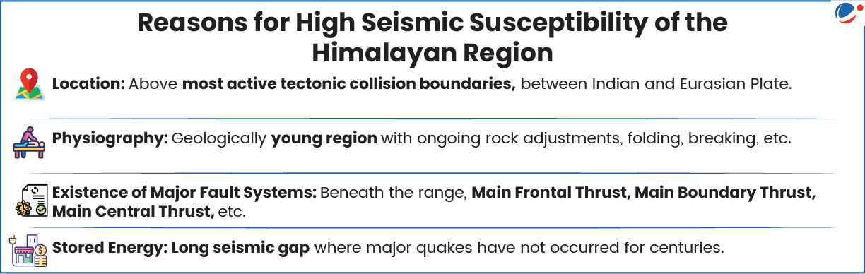
- New Seismic Risk Category (Seismic Zone VI): It places the entire Himalayan arc in this highest risk category due to its high tectonic activity and vulnerability.
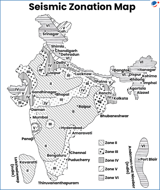
- The revised zone map is based on Probabilistic Earthquake Hazard Assessment (PEHA).
- Existing map had four seismic zones:Zone V (Seismically most active, ~11% of area); Zone IV (~18% of area); Zone III (~30%) and Zone II (Least seismicity, covering remaining area).
- Vulnerability: Places 61% (earlier 59%) of India's land area under moderate to high hazard categories.
- 75% of India's population is in seismically active regions.
- Consistency: Automatically keep towns situated along any boundary separating two categories into higher risk zone.
- Aligns hazard level of areas based on geographical realities rather than administrative boundaries.
- Accounts for Long Unruptured Fault Segments: Includes areas like Central Himalayas devoid of major surface-rupturing event in nearly two centuries.
- Exposure Window: Takes into account population density, infrastructure concentration and socioeconomic vulnerability using Probabilistic exposure and Multi-hazard assessment (PEMA) method capturing not just physical hazard but also impact on communities.
- Safety Requirements for Non-structural elements: Provides that all heavy non-structural components (like parapets, overhead tanks, electrical lines, etc.) exceeding 1% of a building's total weight to be securely anchored.
About Earthquakes
- Meaning: Refers to sudden shaking or trembling of earth causing release of energy along a fault.
- Fault is a sharp break in crustal rocks, along which rocks tend to move in opposite directions pressing the overlying strata, held together by friction.
- Focus and Epicentre: Point where the energy is released is the Focus (or Hypocentre).
- While the point nearest to focus on the surface is the Epicentre. It lies directly above the focus and is the first to experience the earthquake waves.
- Impact: Damage to Infrastructure (buildings, bridges, dams, property, etc.); Loss of life; Trigger other disasters like floods, landslides, tsunamis (e.g., Indian Ocean Tsunami, 2004); Soil Liquefaction, Ground lurching, etc.
- Measurement of Earthquake: Events are scaled either according to magnitude or intensity of the shock.
- Richter Scale: Magnitude scale measuring the energy released, expressed in numbers, 0-10.
- Mercalli scale: Intensity scale taking into account the visible damage ranging from 1-12.
- Major Incidents: Bhuj, Gujarat (2001, Magnitude 7.9); Delhi (2025, Magnitude 4.0); Kamchatka Peninsula, Russia (2025, Magnitude 8.8); Nepal (2015, Magnitude 7.8), etc.
Measures taken to tackle Earthquake Vulnerabilities
- National Disaster Management Authority (NDMA): Formed under Disaster Management Act, 2005, headed by Prime Minister with the state level State Disaster Management Authority.
- NDMA's Earthquake Risk Indexing (ERI) assesses earthquake risks in Indian cities evaluating hazard, vulnerability, and exposure to guide mitigation efforts.
- National Disaster Response Force (NDRF): Formed under Disaster Management Act, 2005, to provide specialised response to natural and man-made disasters.
- National Centre for Seismology (NCS):Monitors earthquake activity across the country and conducts research on developing Earthquake Early Warning Systems.
- National Institute of Disaster Management (NIDM): Developing human resources, training, research, and promoting policies related to disaster management.
- Other Measures: Expansion of seismic observatories to 168 (February 2025); BhooKamp app for real-time earthquake updates, etc.
Way Forward on Effective Management of Earthquake Hazard
- Earthquake Resistant Construction: Incorporate earthquake-resistant features in standard designs for construction of buildings.
- Further, seismic profiling can be quantified for a building in a geographical area especially in case of priority and lifeline structures like hospitals, etc.
- Effective regulation and enforcement: No relaxation in building plans which violate safety parameters to be permissible.
- Creating Awareness: Comprehensive awareness campaign to emphasise the prevalent seismic risk and vulnerability along with highlighting roles and responsibilities of all stakeholders.
- Resilient Urban Development: Retrofitting existing infrastructure and halting expansions on soft sediments or active faults.
Conclusion
Marking a significant shift in India's seismic hazard assessment, the revised map would bring effective changes in building designs and safety especially in Himalayan states and help attain SDG 9 (Industry, innovation and infrastructure) and SDG 11 (Sustainable cities and communities).


